Monday, 29 June 2015

Day 36: From Kunawaritji along Gary Highway

When the sun gets so low the Spinifex shadows are hiding the holes in the road, maybe it’s time to look for a campsite…

Another sunset in a campsite all to myself, but it’s been a (deliberately) long day to get here, and not without it’s dramas… It all started well enough, as most days do. A look around Well 33 on the Canning Stock Route, then a short drive to the nearby relict cattle yards on my way back to the start of the Gary Highway. It’s a bit disappointing to see toilet paper so obvious and within 10m of the camping area. People, burn it or bag it, and for gods sake go further away!
Well 33 on the Canning Stock Route

The stockyards are still here.
The first few kms along the Gary, I was thinking that it was easy. A relatively smooth, 2 lane track. Then the Kiwikurra track branched off and it was immediately apparent that the rougher single lane track heading south was mine… Oh well, it was nice while it lasted, but now down to business. After about 10km I heard a strange rattling noise from under the car. I’d been hearing an occasional rattle before and thought that it was an exhaust mount complaining, but couldn’t find the culprit. Therefore I feared it had finally broken. I looked under the car to see a stick wedged in a gap at the back of the ARB under body protection plating. Not a problem. When I went to remove it, my heart sank. The back of the plating was no longer attached to the car. It had sheared around all 4 mounting bolts and was only held in place by the bolts ahead of it. Now I knew what that occasional rattle had been. Shit!!! Half an hour of scrabbling under the car, with copious swearing later and it’s been fixed the good old bush way. Tie wired back into position to take the strain off the other bolts, then duct taped around the tie wire to stop them moving around. I’ll need to check it every day, but so far it seems to be holding. ARB will be getting an email…

How the Gary Highway started...

Oh, Bugger...
The (very) temporary solution...


The rest of the day went more or less as expected. The track is twisty with frequent washouts, both big and small but thankfully well marked by thoughtful previous users, many drive rounds and frequent corrugations. Average speed of around 40km/h including stops for photos and lunch. Although some places you could go faster, it’s best to drive at a speed where you can stop in less than half the distance you can see clearly ahead. Sounds silly, but the obstacles are frequent enough and often hiding behind a bend that it will pay you dividends, i.e. allow you to have a car still in a driveable condition.
Don't let this good section fool you...

Just before lunch I got to the turn off for the Veevers Meteor crater. This thing wasn’t discovered until 1975, so my hopes for something huge and impressive weren’t great, and I wasn’t disappointed. But it’s a nice drive in with a soft sand dune to go over. A word of warning though. While the rest of the track is passable with a proper off-road camper trailer, the track into the crater isn't. Especially if you do what I did and follow the main track too far and miss where people had ducked out. It becomes high sided and narrower until you can’t go forwards any more. By then this also means the reversing back is also tight. But the diversion is worth it. There's a marker there with an ammo case and visitors book. Apparently there hadn't been many visitors this year, with the previous ones being at the beginning of June.
Maybe I should have taken that go-around?

Plaque at Veevers Meteorite crater

Not long afterwards I saw an old pop top camper by the side of the track. As I was pulling up, and old guy got out. So after checking he was OK I asked about track conditions and other users. Apparently I must have missed the rest of his group while I was at the crater as they were headed for Kiwikurra. Knowing that the track is more used than I thought is both heartening and disappointing.
Another Nissan bites the dust

So I kept driving for longer than I usually would as I figured that another long day tomorrow will see me well onto the Gunbarrel Highway and hopefully through the section shown on the map as having frequent wash-outs. That should then put me in for a short day down the Heather Highway to Warburton, where an early stop will allow me to upload several days blogs and have a bit of a rest before continuing the journey south.

Day 35 Marble Bar to Kunawaritji

A tentative start

Last night I was really worried about this part of the trip. I know I'm capable. My car is more than capable. I just have to keep reminding myself to take it slowly as the consequences for doing something stupid when you’re this remote and by yourself could be severe…

Having said that, the drive to Kunawaritji is quite pretty and an easy intro to the desert. The road is tarmac until you nearly get to Telfer mine, then it turns into (when I travelled it) very well graded track that runs between large, re-vegetated dunes that seem to run for many kilometres. Along the way I stopped to get a photo of the Oakover River where the track crosses it, and started talking to an old guy, Bill, that was doing the same. He was camped for a couple of days just down stream and said it was still running as it was fed by the water from Carawine Gorge. It also turns out he’s the guy that put the brass palques on tracks where they cross the Tropic of Capricorn. When he put the one on the Gary Track, he said he got a call from Len Beadell saying thanks for putting a decent plaque there, but you spelled Gary wrong. It should be Garry! Looks like a lot of maps are wrong as well then…

Oakover River
After Telfer, the track is wide and well graded. Mostly.
It think that's clear enough..?

Then you get to the last 20km before Kunawaritji. Slow Down! It suddenly becomes a lot rougher with corrugations and small wash outs. Also, the Hema Desert Map info for the community is wrong. The shop and servo close at 4pm, not 5pm. I was lucky as the Administrator was tending his veggie patch and opened it up again for me as long as I was paying cash. Half a tank later at $3.40/litre, I drove away with a wallet $280 lighter. Before I left I asked about the camp site listed near the Community. Turns out that isn’t there either. So as dusk was fast approaching, I got directed to the closest one which is only 4km away. I’m spending the night at Well 33 on the Canning Stock Route, and amazingly, I have the place to myself.

Sunset at Well 33 on the Canning Stock Route

Tomorrow sees the start of the Gary Highway, then the Gunbarrel and Heather Highways before I get to Warburton. Eek! It’s less than 400km, but I’m allowing 4 days. Lets see how accurate my guess is…

Day 33 and 34. Broome to Marble Bar

An unexpected post.

A fairly normal start to a big mileage day. Delayed so I could get to Bunnings to get firelighters, the onto Mango coffee. Then the drive started, and what a difference 5 weeks makes. When I drove up, there was a small trickle of caravans heading to Broome/Derby. Yesterday that had turned into a flood. Just really reinforced the value of doing your research on when to go on a trip.

As expected, the volume of traffic fell away when I turned onto the Marble Bar road, but there is one section of note. The road gets to Coongan Gorge just before Maqrble Bar. What a bit of road. Suddenly the flat, boring road is replaced by a lovely twisty road that rises and falls as you go through the gorge. It would be fantastic on a motorbike, but I don't envy the road trains that use it.

Entering Australia's hottest town, unaware of the joy to come...

Drove through Marble Bar to refuel, then went back to the campsite, expecting it to be fairly quiet. How wrong I was. Caravans and tents everywhere, but I managed to tuck myself away in a corner, open the foxwing and roll out the swag. After a quick call to Jen, it was off to the Ironclad Hotel for dinner and a beer. Then things started to go wrong...

Just after dinner, there was a gurgle. So I decided to forego the entertainment at the hotel (Skimpies) and returned to the campsite. Lets just say the reason for the gurgling got worse overnight, so I decided it was probably best to stay here another day to try and get things calmed down a bit. It's now mid afternoon and it's just starting to get better, so hopefully I can continue tomorrow. Otherwise I could be here for a while as Kunawaritji servo is only open Saturday morning, and not at all on Sunday. I need to refuel here to get to Warburton, but won't make it in a morning. So it it's going to happen, it has to be tomorrow...

But now the stomach is calming a bit, it's given me some time to look around the campsite, and it's a pretty strange place. There are several caravans that look like they were parked up and left a long time ago judging by the decay around them. There is a second ablutions block that is out of action and has a couple of old, rusting wrecks dumped in front of it. Oh, and there is no hot water in the showers, but boy, am I glad for a flushing toilet!

One other thing, if you want something to eat when you have diarrhoea, don't go for Weetbix and water. Truly disgusting. Boiled rice is tasty by comparison.

Tuesday, 23 June 2015

Day 32: Broome

The end and the beginning...

Today was the day that Jen flew out, marking the end of a trip that had been a few months in the planning, so it was a little sad in a few ways. But it also marked the start of my trip home, which meant getting the supplies together for 2 weeks of desert travel with probably bugger all resupply opportunities and few fuel stops at community servos along the route.

So as with all desert travel, we start with the preparations. Especially as I'll be doing this bit solo... I'll be keeping the daily blog going, but it will not be updated daily as there is no mobile or wifi for much of the trip. Instead, I'll be keeping in touch with Jen (for safety reasons) through route tracking and checking in on the Spot Tracker, and occasional calls on the satellite phone, both of which have been re-checked in the last couple of days.

So once Jen had gone, I wandered around doing the normal stuff of large shopping trip, but getting mostly cans or soft packed goods as fridge space is limited. It also meant checking the expiry dates on the fresh meat products and reaching to the back of the shelves to get the longest lead time stuff. Worryingly for me (although something I'd usually enjoy) most items are meant for consumption in the next few days. Eek! Although there were a few vacuum packed items that will be kept for later. Then it's the usual gas and fuel refills before hitting the internet for the last minute track checks. Since the roadhouse and community store managers all said the tracks had been used, it's a good sign the trip will be possible, but their comment that conditions vary between rough and bloody rough, or that the last time they saw a grader was probably when Len Beadell passed through may mean my decision to pack food for a fortnight to do an 1800km trip could be useful...

Then to my digs for tonight. The Billi. It's a luxury tent, with no bar or dining facilities on site although there are cooking options in the tent, or a barbecue outside. Sod that! I have to eat my own cooking for the next fortnight. Tonight someone else can do the cooking! And with that, I'm off to the pub. A final Mango beer at Matsos seems in order...

My posh tent

A little bit better than swag on a stretcher bed...

Nice garden setting

Monday, 22 June 2015

Days 30 and 31: Cable Beach Resort, Broome

Rest and repair. For us and the car...

A couple of relaxing days with a bit of running around as I prep for the solo desert legs of the trip. The first day here (I think it was a Sunday?) saw me get a new soldering iron and successfully repair my tyre sensor. How long it will hold is another matter, but I managed to get a couple of spare sensors here, so I'm prepared! I also got a few bolts, nyloc nuts and washers to add to the repair kit for when other stuff starts hanging off. I know a couple will be used soon to re-attach the plastic inner mudguards. The original bolts are still there, so a couple of large washers will cover the hole where they pulled through.

Around mid afternoon we drove onto Cable Beach to try and snag a good spot for when the Camels wandered past, laden with tourists on their sunset ride along the beach. What we hadn't expected was how many other people were doing the same thing! I don't think I've seen that many 4WDs in one place away from one of the shows! Anyway, the smug satisfaction of sitting in a comfy chair with a cold beer in your hand as the camels came past with their bored, uncomfortable and thirsty riders was worth the effort. I wonder if the tourists on camels realised that they were also part of the show as well as observers of it?

Sunset on Cable beach

A small portion of the hoardes we shared the beach with

Sunset had fabulous colours
Standard shot of the camels on the beach at sunset. By the time they came back, I'd drunk my beer so was able to take photos...

Over dinner in the Malay restaurant at the hotel, we started talking about the hotel. We both thinks it's OK, and in many ways good, but it misses that spark or attention to detail that makes you go "wow!" It's almost like it's found it's place in the market, noticed there's no-one competing in the same area, and has taken it's foot off the gas and is just coasting. Dinner in the Sunset bar had one of the best locations in Australia. The food was below expectations. The Malay restaurant food was better, and my lobster was great, but not exceptional. There are no spirits or dessert wines on any menu I've seen so far. The rooms are fine, but the buildings are starting to look a little...faded. The tables are wiped at breakfast with a clean damp cloth, but not dried so you sit down at a wet, smeared table. There is no 24 hour room service. The verbal English of several staff members extends to the menu, but no further, etc. If it wasn't for the location and reputation of this place, I think it would have been overtaken. Which is a shame as I don't think it would take much to restore it to being the premier spot in town.

The second day was more prep and relaxing. Finding that Kimberley Camping is an Aladdins cave of kit, and that some staff Repco Broome don't know their product lines. Then more coffee in Chinatown, a swim in the pool, and a movie at Sun Pictures. A great day, marred only by the realisation that Broome dining closes before 9pm even more comprehensively than Perth!

It's also a sad day. My last full day with Jen for a while. She flies back to Perth tomorrow morning. The car and deserts are going to be quiet without her travelling with me.

Sunday, 21 June 2015

Day 29: Wolfe Creek to Broome

This was never going to be a fun day. 860km or so to do, but at least it's mostly bitumen and there are 2 drivers.

The pack up of camp got done in record time so we had a small amount of time to go and have another look at te crater and get a better shot of it  with less shadow...

Wolfe Creek Metorite Crater
It wasn't until I started reading the boards this morning that I realised this is a rather recent addition to the landscape. It hit only about 300,000 years ago. No wonder it's so well preserved. Another fact garnered from the info boards speaks to the isolation of the place. Although the area has been leased to pastoralists and explored since the 1880s, the crater wasn't identified until the Geological Survey did and aerial survey of the area in 1947...

The rest of the day was thankfully uneventful and we arrived in Broome around 4:30pm to the sumptuous Cable Beach Resort

Day 28: Purnululu to Wolfe Creek

Up, up and away...

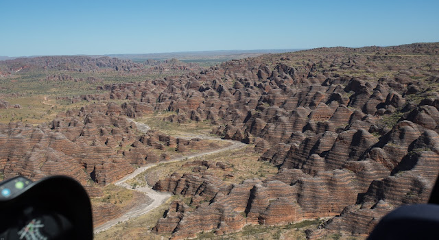
What a way to start the day and celebrate 4 weeks on the road for me. A 40 minute helicopter flight around Purnulu. Unfortunately only the Southern bit, but I guess the northern part doesn't look so good from the air. Even better is that for this one, I was in the front seat next to the pilot. What a view! Truly a highlight of the trip, and neither of us wanted it to end.

Taking off in the prime viewpoint

One of the 'fingers' of Piccaninny

The scale is truly awesome from up here...

One of the world's truly amazing sights

Flying over Piccaninny Creek you start to get an idea of just how little you see whilst walking
Unfortuantely it did, and the reality of a 380km drive reared its ugly head. All well and good to get out of the park, the about 120km of tarmac. Easy… Unfortunately the drive in to the crater takes you down the Tanami Road (Gravel road that links the Kimberley with Alice Springs) for a hundred kms before you turn off onto unmaintained, very corrugated tracks for the final 23km to the crater. We got here just in time for sunset. I don’t hink Jen quite belives we’ll have done a 250km detour to spend less than 10 minutes looking at a meteor crater… oops.

Thankfully, the campsite is right by the crater, and the lamb roast we put in the oven as we left Purnululu was ready to eat (albeit with a bit of an explosion of Fat and juices from the covered roasting tray thanks to the corrugations…)


Best get to bed early tonight as tomorrow is going to be a 10 hour bugger of a drive to Broome…

Day 27: Purnululu, the southern bit.

A walk among the beehives...

Another day where the long walks were being studiously ignored in favour of an easy day with an
early return to camp and cold beer. One difference for today was the resolve to make an early start.
Which, for once, we did.

After a minor detour to the helicopter office to check tomorrow’s flight, it was a short drive to
Piccaninny from where all the walks to todays attractions start.

The awe starts from the drive in. You start to see the domes and it gets better and better as you get closer. 

The start of that layered sandstone and unique weathering...

First sight of the beehives

Then you get to the carpark and realise that all the promo shots are just of a very small corner of this area, which in itself is a very small corner of the National Park. So, after a brief pause to pick up your jaw, you start on the first walk which is part of The Domes Loop. Wow. No conglomerate today, just banded sandstones, but just as sensational. 

Starting the Domes loop

From here the walk carries on into Cathedral Gorge where the beehives are temporarily replaced by high gorge walls before suddenly opening into the "Cathedral" at the end.
You can imagine this place being popular with Aboriginals for the helter it would provide, but the
pool was one you wouldn’t want to bathe in, let alone drink

The entrance to Cathedral Gorge

Taking in the scene

Cathedral Gorge is quite a large place...

Then the path followed the creek bed towards what for us would be the furthest point, The Window. You can follow it for another nearly 20km up intp Piccaninny creek. I had cold beer calling. The Window itself is not overly impressive, but the walk there is picturesque as it’s a continuation of the beehive and gorge formations. The on our way back we took a detour into Piccaninny creek lookout. This detour is worth the effort as we got a slightly elevated viewpoint towards the gorges.

Walking up Piccaninny Creek

The patterns caused in the riverbed by boulders in the turbulent flow are nearly as cool as the Beehives themselves

The view from Piccaninny lookout

With beehive overload, it was time to head back to the car. It’s about now we realised that our slow saunter had kept us wandering around the area for nearly 6 hours. Maybe I’d better thave a couple of beers. Rehydration purposes, of course…

Day 26: North Purnululu

Since Mini Palms Grove is closed while they rebuild a some of the walkways, today was always going to be fairly relaxed. We were going to start with a drive to the Bloodwoods lookout, then Echidna Chasm and Osmand Lookout. How quickly plans can change. We got to The Bloodwoods, and saw the comment of Homestead Valley only being 2.2km along an easy track… Its worth the minimal effort required.

The walk into Homestead Valley


Homestead is a lovely gorge, but then you walk down Echidna… The best time of day is just before midday when the sun turns the walls of the chasm fabulous shades of orange, yellows and reds. It’s narrow walls also mean it stays shaded and add to the dramatic effect.

Bowerbird nest

A tour group leaving the chasm

Je walking into the far end of Echidna Chasm

Jen surveying the scale of Echidna Chasm

You can’t walk through these chasms/gorges without commenting on the rocks you walking past. The poorly sorted conglomerate consists of a well rounded clasts ranging in size from pebble to large boulders, in a sandstone matrix; while the dark sandstone banding still contains occasional horizons of pebble sized clasts. The dark colour is apparently caused by cyanobacteria . The energy required to transport this far enough for the clasts to become rounded is mind boggling. The thickness the unit says that this was a regular event in the Devonian  at this location. I will need to get the GSWA notes on the area as this is fascinating…


Finish the day with another short walk and scramble to a lookout to watch sunset strike the Bungles. All with a cold beer in our hands. Bliss. Even better is returning to find we still have a quiet campsite!

Sunset from a vantage point with a cold beer. Jen finds her happy place.

Day 25: Lake Argyle to Purnululu

A short blog entry today with only one photo from tonight. Although I wish I had some from the journey here…

A later than planned start due to the friendliness of our neighbours and their friends, but the sense of relief as the campsite faded into the distance was palpable. With these happy thoughts, we settled into the 350km drive starting with a splash and dash of fuel from Kununurra.

The minute we started on the Great Northern Highway the scenery started to change, and it changed a few times before the turnoff into Purnululu. In short, “oh wow” was said a few times. But enough from me, just drive it for yourselves.

Once we got onto the Purnululu track, it was 53km of fabulous, but not too difficult, twisty track. A few water crossings. A few small corrugations. A few crests at the top of a switchback. Fun, low speed driving.

That campsite itself for the next few days is Kurrajong. By all accounts it’s a lot quieter than Walardi, which is fabulous after Lake Argyle. Our neighbour  is about 100m away.


Time to settle in for the night with a couple of beers and that bottle of Pepperjack we’ve been carrying since Wyndham. Unfortunately it’s my turn to cook, so some restraint will have to be shown. For now…

There was the odd star or two visible at night...

Saturday, 20 June 2015

Day 23: Wyndham to Lake Argyle

The day starts with the promise of coffee, a walk on a jetty, then a Barramundi burger brunch. The first two happened...So a shack called The Rusty Shed does OK coffee, and the 5 Rivers CafĂ© doesn’t open for brunch on Sundays.

Wyndham Jetty

But Wyndham was more than this. The Historical Society has opened a museum which deserves more fanfare than it gets. It’s an awesome portrayal of Wyndham, both good and bad. Everyone should visit. Then there is the fuel price. As Wyndham is a deep water point, the fuel is landed here for the region and consequently is $1.50 a litre! Plus the servo is a little gem. Looks like bugger all from the outside, but… I got a replacement antenna for the UHF for $40. Might not be the best quality, but better than what was there (i.e. a broken off stump)

An old Sunbeam that I think might be a bit past repair... 
Ideas on when this was taken? Unfortunately it's the 20th Century.

A reminder of Wyndham's link to Pastoralists


A mostly uneventful drive to Kununurra where we were both sooo grateful for a Coles and the choices therein.

So a mostly good day, made better by the change of scenery as you pass Kununurra heading east which just gets more impressive as you turn off towards Lake Argyle. Then you get to the resort… Some people here love it and have been here for days or weeks. I’m not one of them. As you drive in you immediately notice how closely packed the motorhomes and double axle caravans are. And how many of them there are. I think we’ve found the Grey Nomad Long Term Storage facility from where they are trickled back onto Aussie roads at the end of each dry season. Then when you check in you’re given a wristband to identify you as a resident, not a day guest. You’re not shown your camp site on a map, you have to wait to be shown where it is, etc. While I understand why they do this with such a busy camp and some people love this degree of organisation, for me it adds to the stifling feel of the place. Add into this a singer that sings everything in an upbeat tempo and key, including the likes of Bob Dylan and James Blunt, (think along the lines of acoustic lift music) and you have something close to my vision of hell.

Having said that, I wanted to come here. The place is stunning and I'm still looking forward to tomorrow’s sunset cruise on the Lake. But I'm also really glad we’re heading back offroad to bush camps the day after… where these buggers can’t follow! I've seen enough examples of people that can’t tow, let alone the behemoths that they are currently towing, or failing to reverse (there really should be a competency test for this) that I'm really looking forward to the peace of the desert again.

Day 22: El Questro to Wyndham

A simple day starting wth brekkie at the township. The Emma Gorge on the way out. For those of you that haven't been there, its a bit of a walk and scramble in, but nothing like as bad as El Questro. It's worth every step. The pool at the end of the gorge is amazing. It's used in so much of the Kimberley promotional material for a reason! What that blurb doesn't tell you is that there are hot springs on the right hand side,so if you go under the overhang, you get warm water falling on you, and then you find the small warm pool tucked behind some rocks...

Just a sensational swimming spot and well worth the short scramble to get there

But all good things must come to an end and we headed for Wyndham. Got to the campsite and both had a huge desire to not have to muck around setting up camp again so we booked into a cabin. So far we have followed two recommendations. Firstly to go to 5 rivers lookout for sunset, the to go to the Community club for dinner.

The 5 Rivers lookout is the best of the trip so far. It redefines the term "Panoramic" with it's 270 degreed views over Wyndham and the Ord and Pentecost rivers systems.

View north west. Wyndham Port is just out of shot in lower left corner

Wyndham Port at Sunset


Dinner nearly didn't happen. We got to the Club and walked in... and weren't sure if it was a good idea. The we saw that either Lamb roast, Lasagne or Beef Stir Fry were all $12, and suddenly everything was fine.  Then we noticed that the block wall was painted in places. It appears that over the past 25 or so years, people have paid to have one or more blocks painted with a motif of their choosing to support the club

There's more to see here, but we won't have time. Even to wet a line...